Magellan SporTrak Pro Waterproof Hiking GPS
Now there’s a sporty, pocket-sized GPS system with 32MB of built-in memory. The Magellan SporTrak PRO is light to carry but heavy on detail with more basemap and uploadable memory than the competition. It’s equipped with a full keyboard, large screen, and the best antenna on the market for portable applications. The full 3D topo
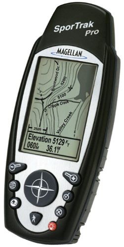
Now there’s a sporty, pocket-sized GPS system with 32MB of built-in memory. The Magellan SporTrak PRO is light to carry but heavy on detail with more basemap and uploadable memory than the competition. It’s equipped with a full keyboard, large screen, and the best antenna on the market for portable applications. The full 3D topo support has intelligence behind it, so you can actually query the topography. Yet it’s packed into a mere 6.1-oz. so you can carry it in your jacket pocket. Special features include save track to route, satellite status display, built-in help, northfinder with sun/moon positions, sunrise/sunset calculator, best fish & game calculator, horizontal profile and address search. 5-3/5Hx2-1/5Wx1-3/10D”.Amazon.com Product Description The Magellan SporTrak Pro is a feature-rich, fun, and easy-to-use GPS receiver designed for the serious navigator. Its rugged, waterproof, and ergonomic design is perfect for the outdoorsperson needing a compact but powerful navigator.
Included in SporTrak Pro is a 9 MB North American basemap of highways, major roads, parks, waterways, marine navaids, buoys, lighthouses, and more. An additional 23 MB of built-in memory is included for downloading detailed maps from Magellan’s MapSend line of CD-ROMs. With Wide Area Augmentation System (WAAS) support, the SporTrak offers readings with up to a three-meter accuracy.
The large display, along with a front facing 9-key keypad, makes it easy to use in any environment. SporTrak Pro software includes seven graphic navigation screens, storage for up to 500 waypoints and 20 routes, a best fish and game time calculator, and BackTrack for finding your way home after a long trip into the woods.
The SporTrak Pro runs on two AA batteries for up to 14 hours. It’s housed in rubber-armored, impact-resistant plastic that’s waterproof and also floats.
The WAAS difference
 100 meters: Accuracy of the original GPS system, which was subject to accuracy degradation under the government-imposed Selective Availability (SA) program. 15 meters: Typical GPS position accuracy without SA. 3-5 meters: Typical differential GPS (DGPS) position accuracy. Less than 3 meters: Typical WAAS position accuracy. WAAS is a system of satellites and ground stations that provide GPS signal corrections, giving you even better position accuracy. How much better? Try an average of up to five times better. A WAAS-capable receiver can give you a position accuracy of better than three meters 95 percent of the time. And you don’t have to purchase additional receiving equipment or pay service fees to utilize WAAS.
How it Works
WAAS consists of approximately 25 ground reference stations positioned across the United States that monitor GPS satellite data. Two master stations, located on either coast, collect data from the reference stations and create a GPS correction message. This correction accounts for GPS satellite orbit and clock drift plus signal delays caused by the atmosphere and ionosphere. The corrected differential message is then broadcast through one of two geostationary satellites, or satellites with a fixed position over the equator. The information is compatible with the basic GPS signal structure, which means any WAAS-enabled GPS receiver can read the signal.
Who benefits from WAAS?
Currently, WAAS satellite coverage is only available in North America. There are no ground reference stations in South America, so even though GPS users there can receive WAAS, the signal has not been corrected and thus would not improve the accuracy of their unit. For some users in the U.S., the position of the satellites over the equator makes it difficult to receive the signals when trees or mountains obstruct the view of the horizon. WAAS signal reception is ideal for open land and marine applications. WAAS provides extended coverage both inland and offshore compared to the land-based DGPS (differential GPS) system. Another benefit of WAAS is that it does not require additional receiving equipment, while DGPS does.


 100 meters: Accuracy of the original GPS system, which was subject to accuracy degradation under the government-imposed Selective Availability (SA) program. 15 meters: Typical GPS position accuracy without SA. 3-5 meters: Typical differential GPS (DGPS) position accuracy. Less than 3 meters: Typical WAAS position accuracy. WAAS is a system of satellites and ground stations that provide GPS signal corrections, giving you even better position accuracy. How much better? Try an average of up to five times better. A WAAS-capable receiver can give you a position accuracy of better than three meters 95 percent of the time. And you don’t have to purchase additional receiving equipment or pay service fees to utilize WAAS.
Comments